A.D.A.M. Security Assessment Platform

Plan site and event security with a shared view.

An A.D.A.M. Corp product in development for verified government agencies, police departments, and licensed security teams. Connect site layouts, protective resources, people, critical assets, and changing conditions in one reviewed plan.

In developmentSite and event focusVerified professional access

Planned for Android, iOS, and web. From field observations to printable plans and future site design.

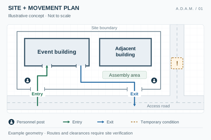
Illustrative site plan with separate entry and exit paths through shown openings, personnel posts, an assembly area, and a temporary road condition
Site plan concept · Not to scale; routes and clearances need verification. View full site plan
Planned capabilities

Assess the whole site and event.

Build a baseline, evaluate changes, and preserve the reasons behind the plan. These capabilities are planned and will be validated before operational use.

01 · Buildings and design imports

Start with the actual layout

Bring supported CAD, BIM, and floor-plan files into a registered site view. Record levels, heights, roofs, occupancy, openings, and circulation with scale, source dates, and verification status.

02 · Ingress and egress

Plan movement and access

Connect pedestrian and vehicle approaches, screening, entrances, exits, emergency routes, and assembly areas. Review closures, accessible routes, clearances, and competing uses.

03 · Cargo and equipment

Make dimensions part of the plan

Place protected cargo and sensitive equipment using measured dimensions and handling envelopes. Assess staging, transfer routes, custody, coverage, and documented operating constraints.

04 · Cameras and coverage

Evaluate the equipment you have

Plan bullet, dome, PTZ, fisheye, panoramic, and thermal cameras with documented optics, weather housings, settings, and field evidence. Compare placement and usable views while distinguishing PTZ schedules, dewarped images, and the deployed baseline.

05 · Personnel and proximity

See each post in context

Display Observe, Assess, Prepare, and Respond zones around personnel posts, with configurable radii and secondary color cues. Link each zone to approved role procedures and conditions; color or distance alone cannot authorize force.

06 · Changing security posture

Review the effects of a change

Compare protective positions, resources, barriers, and routes when a threat or condition is introduced. Keep authorization, communication, acknowledgement, and confirmed implementation visible.

07 · Landscape, river, and weather

Account for the wider environment

Connect terrain, elevation references, river conditions, lighting, and historical disruptive weather. Assess effects on access, traffic, operational timing, resources, and response alternatives with visible uncertainty.

08 · Crowds and venue check-in

Evaluate people and flow

Assess zone counts, density, screening queues, arrival and departure assumptions, and venue check-in. Show uncertainty, stale counts, bottlenecks, and conflicts with response access.

09 · EMS coordination

Build response access into the venue

Plan medical posts, EMS staging, responder ingress, pickup, and egress. Provide authorized activation procedures, recorded outcomes, and manual fallback without implying a request confirms dispatch.

10 · Mitigations, protocols, and rules

Keep recommendations traceable

Match findings to a maintained mitigation catalog, approved protocols, and applicable state-specific requirements. Explain prerequisites, alternatives, conflicts, sources, coverage gaps, and limits for review.

11 · Printable assessment packages

Take the reviewed plan with you

Print authorized site images, floor plans, posture comparisons, recommended protocols, and reports. Preserve legends, source attribution, revision status, scale limitations, and redactions.

12 · Future security planning

Compare what exists with what comes next

Reuse a verified baseline for new events, renovations, buildings, and phased improvements. Compare design alternatives and reconcile the implemented site with the approved plan.

13 · Critical and controlled facilities

Plan around the facility's obligations

Connect essential infrastructure, service dependencies, and approved facility protocols. ITAR-controlled contexts need reviewed applicability, recipient access, data handling, and export controls before protected information is processed.

14 · A.D.A.M. risk methodology

Keep risk and decisions explainable

Develop an A.D.A.M. matrix for likelihood and consequence across people, operations, services, assets, environment, and controlled information. Urgency, evidence confidence, and authorized actions remain separate. The draft method requires validation.

15 · Authorized ALPR integrations

Connect vehicle observations to the plan

Plan connections to approved license-plate recognition providers. Review vehicle arrival trends, permitted alerts, and timing impacts with source dates, access rules, retention limits, and human verification. Provider availability and permitted analyses require validation.

16 · Fences, gates, and barriers

Plan the perimeter in detail

Compare fence styles, rolling/sliding, lift-arm, accordion, and other gate mechanisms with protective barriers. Review measured layouts, assembly evidence, travel space, weather, deployment, and emergency access before accepting a protective plan.

17 · Anti-terrorism protective planning

Connect protective measures and readiness

Link credible scenarios to layered protection, approved separation areas, suspicious-item reporting, response access, and continuity. Keep specialist review, evidence, uncertainty, and exercised procedures visible. A fence label or map ring cannot establish certified protection.

18 · Sensors and controlled access

Connect equipment to access and safety

Plan motion sensors, automatic doors, vestibules, readers, handles, and critical-asset locks. Connect staffed verification to current authority and permitted information. Review dimensions, failure modes, emergency release, custody, and maintenance alongside crowd, cargo, and EMS routes.


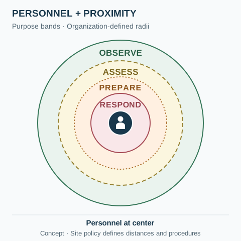
A personnel symbol centered in four distinct purpose bands labeled Observe, Assess, Prepare, and Respond, with line patterns and secondary colors
Proposed proximity view · Distances and procedures require approved site policy. View full proximity diagram
Personnel-centered planning

Give proximity a clear purpose.

Each post can have distance bands linked to that person's role and approved engagement procedures. Select a band to see its range, applicable conditions, responsibilities, and communication steps.

  • Observe: maintain awareness and report changes
  • Assess: verify conditions and potential disruption
  • Prepare: coordinate readiness and resources
  • Respond: follow the authorized incident procedure

These are proposed purpose labels. Color supports recognition; the organization defines the radii and rules for its site. Actions also depend on the event, observed behavior, legal authority, and supervisor policy. Proximity or color alone never authorizes force.

Operational integrity

Protect the purpose of the operation.

A threat is a condition, event, action, or failure that could disrupt the intended purpose, safety, or essential functions of an event or operation.

Define expected conditions for each phase. Assess changes against that baseline and their possible impact, whether they involve people, weather, crowds, routes, equipment, or communications.

Make each decision explainable

An unexpected change starts an assessment. The plan connects evidence, uncertainty, possible disruption, and urgency to applicable mitigations and approved procedures.

Distance identifies a planning zone. The situation and the responsible person's authority determine the response. An ordinary arrival can be close to a post; a distant flood warning can still affect the operation.

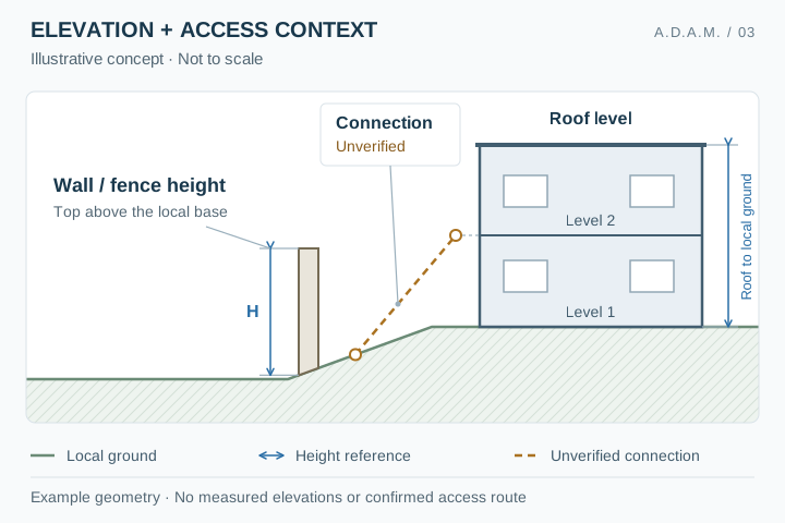
Illustrative building levels and wall height referenced to local ground, with a diagonal connection marked unverified outside the building
Elevation concept · Not to scale; elevations and access remain unverified. View full elevation diagram
Height and access context

Assess protection across levels.

Plan wall and fence heights against local ground, building floors and roofs, terrain, and adjacent structures. Review documented vertical or diagonal connections, temporary works, sightlines, and the permission to use each route.

Connect each finding to what the operation must preserve, the supporting evidence, applicable protective options, and the responsible reviewer. A nearby elevated feature starts a contextual assessment; it does not automatically establish a threat or usable access path.

Android · iOS · Web

One accountable plan, in the office and the field.

The product is being designed for installed Android and iOS apps and a web workspace, with shared assignments, revisions, and permissions.

Field capture, touch planning, review, and printing connect to the same evidence. Device limits, offline drafts, source accuracy, and unsupported analyses stay visible. Human reviewers remain responsible for approving the plan.

Designed for controlled collaboration

  • Organization and individual verification before protected access
  • Explicit permissions for each assignment
  • Source dates, revision history, and evidence provenance
  • Independent review and controlled report exports

Viewing this page or contacting A.D.A.M. Corp does not grant product access.

Proposed assessment workflow

From site context to reviewed findings.

A connected workflow for planners, field contributors, and designated reviewers.

  1. DefineRegister the site or design, dimensions, event, phases, and sources.
  2. ConfigurePlan resources, proximity zones, cargo, crowds, routes, and EMS.
  3. AssessCompare changes, evidence, environmental effects, and applicable protocols.
  4. ReviewApprove the revision, coordinate changes, and print authorized plans.
Prospective pilot discussions

Help shape the first assessment workflow.

Contact A.D.A.M. Corp with your organization, role, and general site or event needs. We will discuss fit, verification, scope, and availability. Keep sensitive plans and security evidence out of public email.

Discuss a pilot